Innovation doesn’t just happen in laboratories or development centres. It often depends on people who develop their professional expertise over the long term and in a systematic way. One of them is our colleague Oto Weber from Lovochemie, who successfully graduated last year from the Faculty of the Environment at UJEP with a degree in environmental geoinformatics – his studies were made possible under a qualification agreement. The result of his dissertation is a unique digital twin of the Lovochemie production site. The project, which has also attracted the attention of experts, is now delivering tangible benefits for the safety, management and further development of our plant.
Oto Weber has been working as a GIS (Geographic Information System) specialist at Lovochemie for more than ten years. As part of its remit, it focuses on the development and management of geoinformation tools that are essential for the effective management of sites, infrastructure and data. Thanks to the company’s support, he was able to further his professional development and enhance his qualifications by studying at the University of Jan Evangelista Purkyně, where he specialised in environmental geoinformatics.
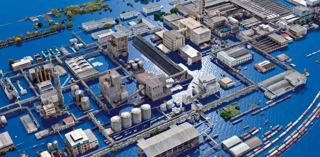
The topic of his dissertation was closely linked to practical needs: to create an accurate virtual 3D model of the Lovosice chemical production site, which would serve as a tool for spatial analysis, development planning and crisis simulation. It was not a theoretical experiment, but a project with direct practical applications.
How the digital twin of the site was created
The digital twin was created using contactless spatial data collection via aerial drones. These were equipped with a standard photogrammetry camera and a LiDAR laser scanner. The result is tens of thousands of photographs and millions of data points capturing buildings, technological installations and the surrounding terrain.
By combining these methods, a geometrically accurate and visually realistic 3D model of the entire Lovochemie site was created. A new high-resolution orthophoto map, with a resolution of approximately 3 cm per pixel, was also created using the same data. The result is a detailed digital image of the entire plant, which corresponds to reality with exceptional accuracy.
What makes this project so special is, above all, its scale. Models of this level of detail are typically produced for individual buildings, rather than for an entire industrial site of this size. Processing this enormous volume of data required parallel computing on the faculty’s ten most powerful computers. This, too, demonstrates the complexity and technical sophistication of the work as a whole. Furthermore, collecting data at the chemical site was logistically challenging – it was necessary to coordinate drone flights, movements on the railway siding and safety measures, which were overseen by the company’s fire brigade. The company ArcDATA PRAHAalso collaborated on the project.